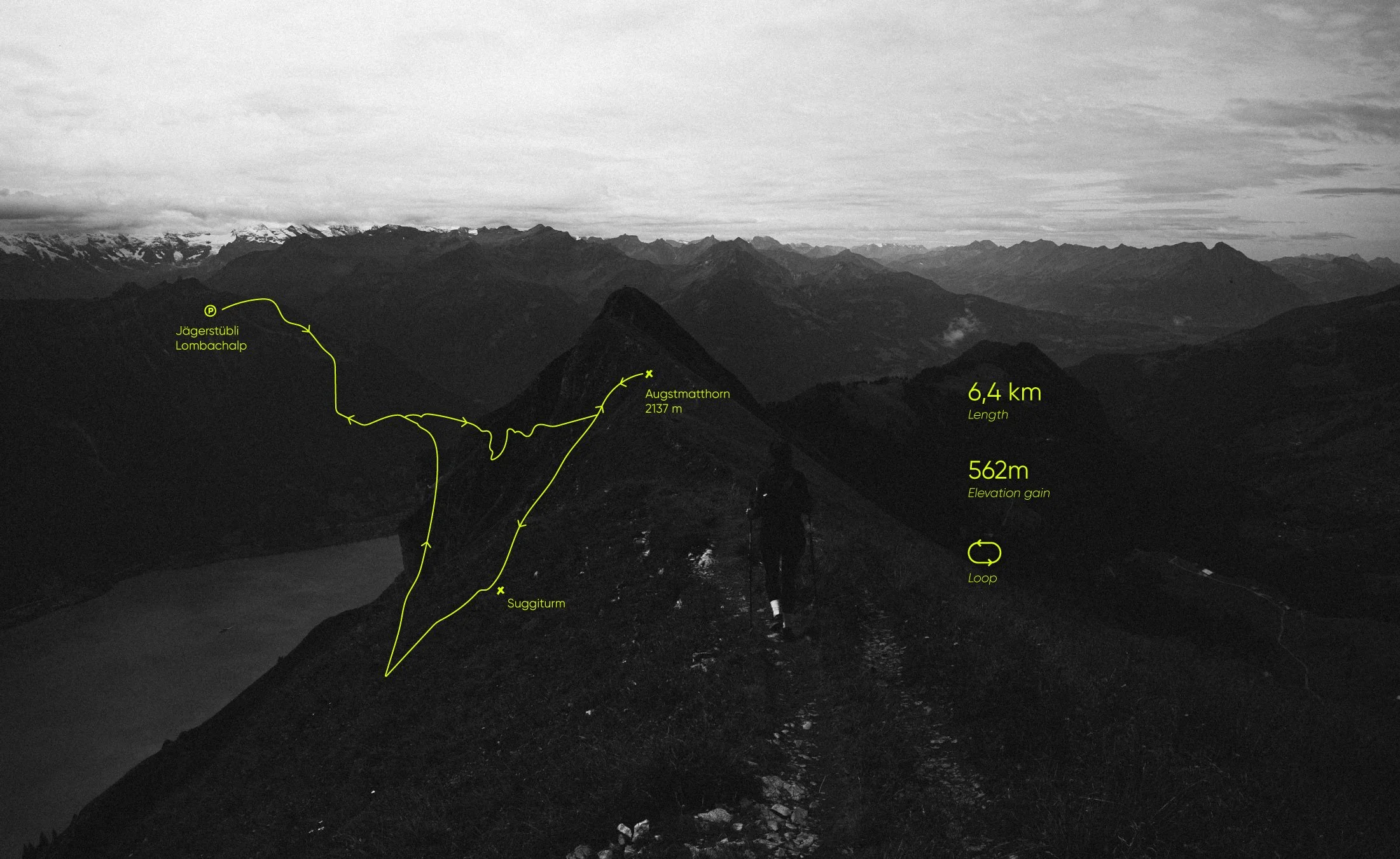
Augstmatthorn – Suggiture
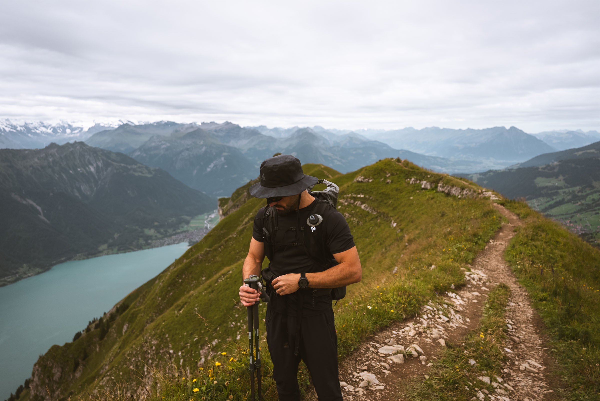
This hike runs along the Brienzergrat ridge, inside the Hohgant Nature Park, and it’s one of those routes that reminds you why Switzerland never gets old. Sharp ridgelines, open alpine terrain, and constant views down to Lake Brienz — almost the entire loop feels exposed in the best way.
The route links two summits: Augstmatthorn (2137 m) and Suggiture (2085 m). From both, you get wide panoramas over the Bernese Oberland, with a clear line of sight across the Brienz ridge peaks. On a clear day, it’s hard to stop moving because every few minutes the perspective changes.
I did this loop starting from Lombachalp, following the ridge in a logical, flowing way. The terrain is partly rocky, fully alpine, and very exposed to the sun — no forests to hide in once you’re up high. Bring water, move early, and don’t underestimate the heat on warm days.
Key stats
Distance: 6.4 km
Elevation gain: 562 m
Type: Loop
Highest point: 2137 m (Augstmatthorn)
Difficulty: Challenging (due to exposure and terrain, not technical climbing)
What it feels like on the ground
This is not a “casual stroll” hike. The trail is well defined, but sections are rocky and exposed, especially along the ridge. There’s no scrambling that requires hands for long periods, but sure-footedness matters.
Because it’s a popular route, you’ll likely meet other hikers — especially between May and October. When I did it, the trail itself felt well spaced, but two main viewpoints were noticeably busy. People tend to stop there to sit, eat, and take photos, which creates small bottlenecks. Outside of those spots, the flow was smooth.
Despite the popularity, it never felt overcrowded in a bad way — just shared.
Best time to go
May to October is the prime season.
Earlier in the year, snow can linger on north-facing sections, and in shoulder season you should always check conditions before committing.
Because the route is fully exposed:
Start early on hot days
Wind can be strong on the ridge
Weather changes are very noticeable once you’re up high
Dogs on the trail
Dogs are allowed on this route, and I did see a few along the way. In some areas they can be off-leash, but always double-check local regulations and be realistic about exposure and heat — this isn’t a shaded forest walk.
Navigation & GPX
I’m sharing the GPX track for this route on this page.
A quick note:
This GPX is shared for reference, not as a substitute for judgment. Always:
Check weather and trail conditions
Adjust your plan to your level
Don’t blindly follow a line in fog or bad weather
If you’re new to ridge hiking, take your time and enjoy it — this is a route meant to be savored, not rushed.
Final thoughts
Augstmatthorn – Suggiture via Lombachalp is popular for a reason. It’s short enough to fit into a half day, but scenic enough to feel like a big alpine experience. If you want a pure ridge hike with constant views and no unnecessary detours, this loop delivers.
I’ll be sharing more itineraries like this — routes I actually hike, not just maps pulled from the internet. If you came here from Instagram, you already know the deal.
👉 Want the GPX?
If you found this useful, the GPX is available down there.
And if you want more alpine routes like this, follow along on Instagram and Youtube — that’s what keeps me motivated to keep sharing.
Distance: 6.4 km
Elevation gain: 562 m
Type: Loop
Highest point: 2137 m (Augstmatthorn)
Difficulty: Challenging (due to exposure and terrain, not technical climbing)
This route is free to download.
If you’d like to support Slow Road Studio and the creation of free itineraries, GPX files, and guides, you can contribute here.