Üssers Barrhorn (3610 m)
Turtmann Valley Route – The Highest Non-Technical Summit in the Alps 🇨🇭
Üssers Barrhorn is often described as the highest non-technical hiking summit in the Alps.
At 3610 meters, it offers a true high-altitude experience — without glacier travel, ropes, or mountaineering skills.
But don’t mistake “non-technical” for easy.
This route is a serious alpine effort.
Quick Facts
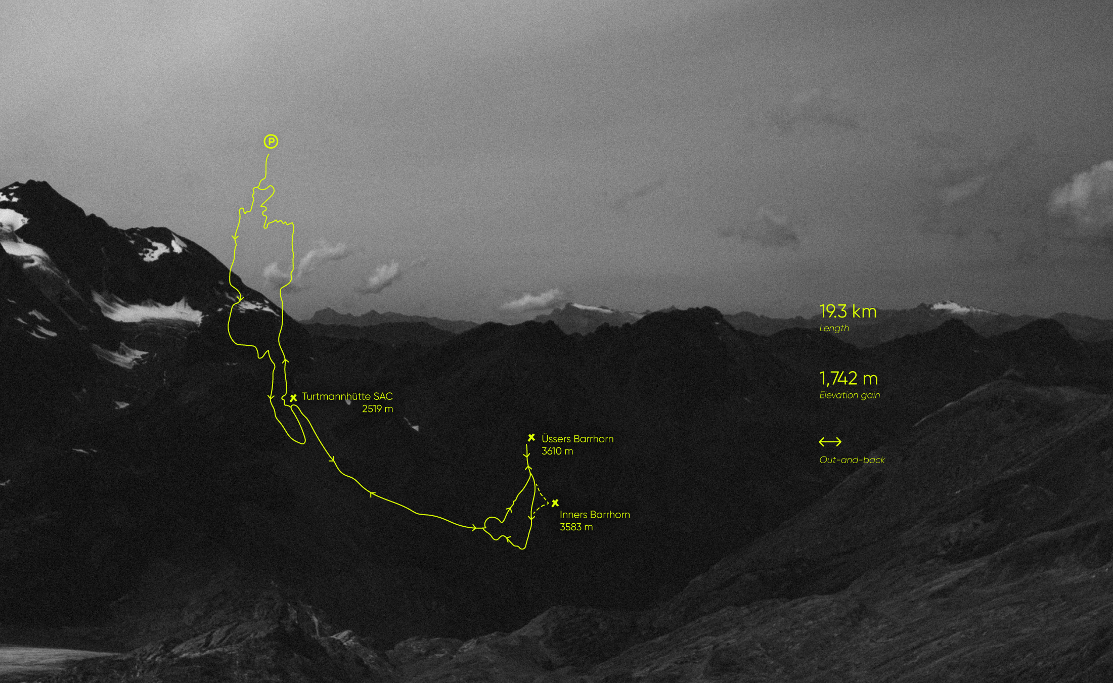
Location: Turtmann Valley, Valais, Switzerland
Summit elevation: 3610 m
Distance: 19.3 km (out & back)
Elevation gain: 1,742 m
Type: Out-and-back
Difficulty: Very challenging
Best season: July–September
Route Overview (Turtmann Valley Start)
The trail begins in Turtmann Valley, just before the small bridge where the Gruben road crosses the Turtmänna stream.
From there:
Gradual climb toward the reservoir
Continue to Turtmann Hut (2519 m)
From the hut, the terrain becomes fully alpine
Final sustained ascent to the summit ridge
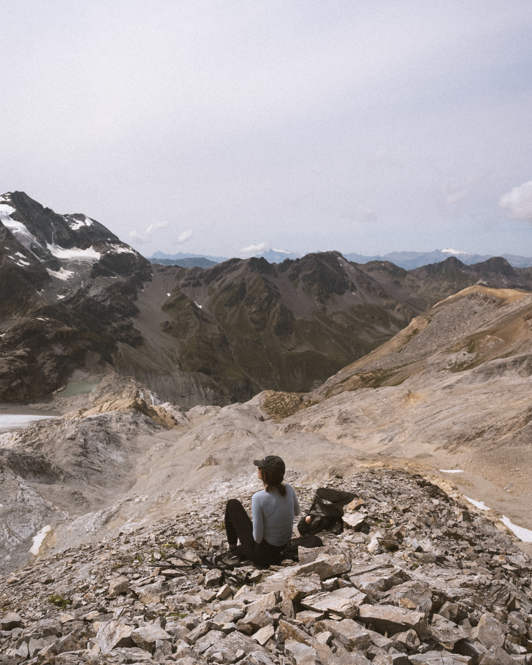
Broad rocky summit marked by a cross at 3610 m
No glacier. No technical climbing.
But nearly 1,750 meters of vertical gain in one push.
What Makes This Route Demanding
This is a true alpine hike:
Long continuous ascent
High altitude above 3000 m
Fully exposed terrain
Rocky sections and some steel cable assistance
Rapid weather changes
Above 3200 m, you feel the altitude.
Above 3400 m, every step becomes deliberate.
This is not a casual summit.
How Hard Is It Really?
Physically: Very demanding
Technically: Advanced hiking (T3–T4)
Mentally: Stable if weather is good
The difficulty comes from:
Duration
Elevation gain
Altitude
Exposure
If you are not used to 1500m+ days, this will test you.
Conditions & Best Time
Best done July to September.
Earlier in the season:
Snowfields may remain
Ice can form overnight
Always check:
Wind speed (ridge is exposed)
Thunderstorm risk
Temperature at 3600 m
Fog forecast (navigation becomes serious)
Wildlife & Regulations
The route lies within Pfyn-Finges Nature Park.
Dogs are allowed but must remain on a leash.
Respect wildlife and alpine vegetation.
Marmots are common along the lower sections.
Water & Logistics
Limited water sources higher up
Start early
Carry enough water
No shade for most of the climb
Return follows the same route.
Who Is This For?
This hike is for:
Experienced alpine hikers
People comfortable with altitude
Strong endurance athletes
Those seeking a serious day objective
Not recommended for:
Beginners
Poor weather days
Late starts
Is It Worth It?
Standing at 3610 meters without crampons or rope is rare.
Barrhorn is not dramatic because it is technical.
It is dramatic because of altitude and scale.
It feels big.
GPX & Full Track
I’m sharing the full GPX track for this route here :
⚠️ GPX is for reference only.
Always adjust your plan to conditions and your level.
Location: Turtmann Valley, Valais, Switzerland
Summit elevation: 3610 m
Distance: 19.3 km (out & back)
Elevation gain: 1,742 m
Type: Out-and-back
Difficulty: Very challenging
Best season: July–September
This route is free to download.
If you’d like to support Slow Road Studio and the creation of free itineraries, GPX files, and guides, you can contribute here.